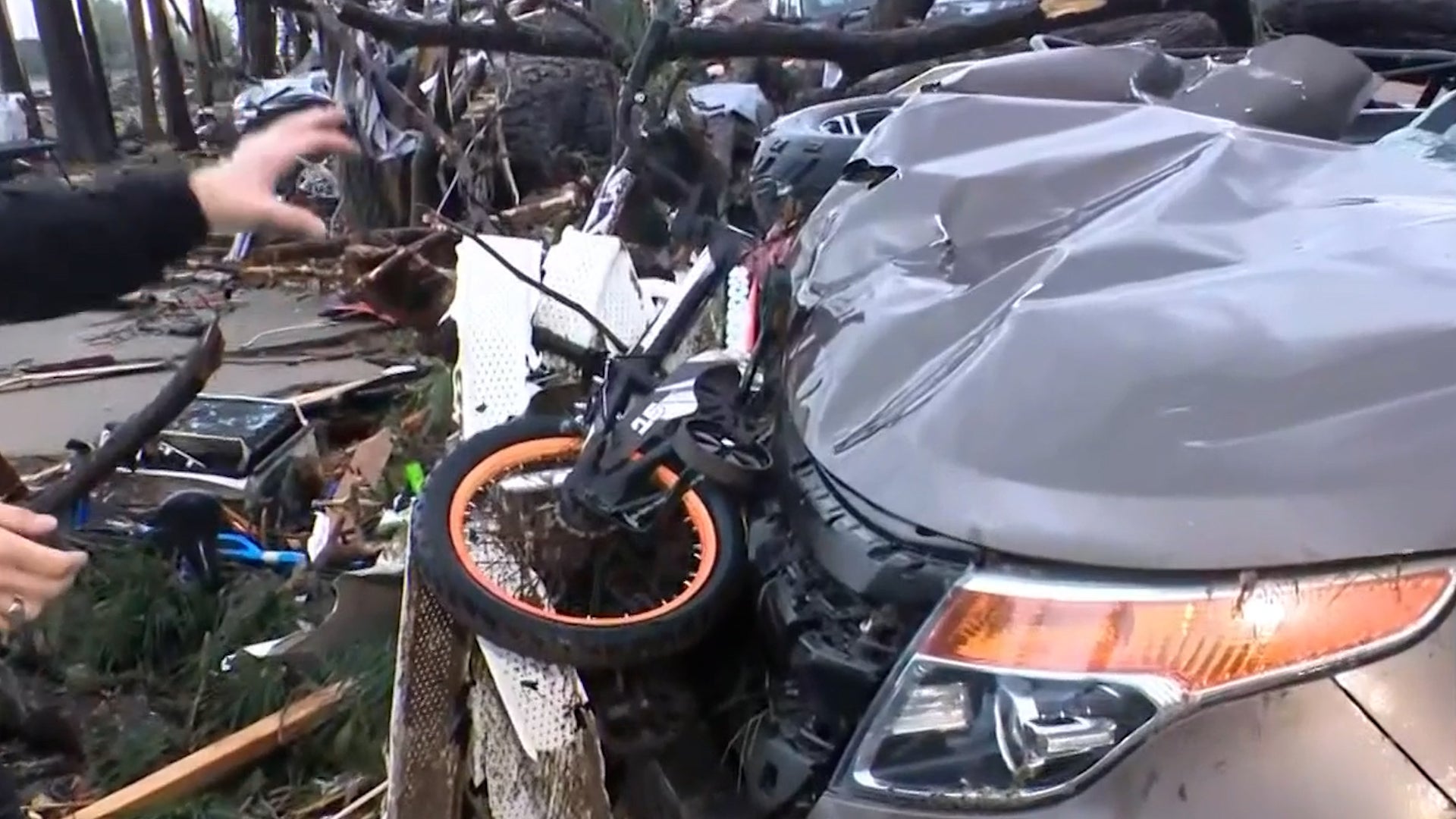
Woensdrecht, Nederland

8:46 AM CEST op 21 mei 2013 (GMT +0200)
Hoogte: 56 ft
Lengte: 4.3° E
Breedte: 51.5° N
Updates van ‘Rapid Fire’™
Geactualiseerd 7:46 AM CEST Haal uw gratis Weather Sticker® op Share:
Your Custom Weather Sticker®

Copy the following lines of HTML:
News
May 20, 2013
Moore, Oklahoma is no stranger to devastating tornadoes.
May 20, 2013
The Salvation Army says it is activating disaster response teams and mobile feeding units to help residents and rescuers in Moore.
May 20, 2013
Several children have been pulled out of the rubble alive at a school in an Oklahoma City suburb.
May 20, 2013
Homeland Security Secretary Janet Napolitano is assuring Oklahoma's governor that the Obama administration will provide all possible help to the state after a massive tornado tore through the Oklahoma City suburbs.
May 20, 2013
A monstrous tornado as much as a mile wide roared through the Oklahoma City suburbs Monday, flattening entire neighborhoods, setting buildings on fire and landing a direct blow on an elementary school.
May 20, 2013
Catastrophic tornadoes developed in Oklahoma on Monday. Here are photos and social media reports.
May 20, 2013
The moon has a new hole on its surface thanks to a boulder that slammed into it in March, creating the biggest explosion scientists have seen on the moon since they started monitoring it.
May 20, 2013
Chinese authorities say rainstorms that battered southern China this week have killed 55 people and left 14 others missing.
May 20, 2013
A tornado outbreak struck the Plains states on May 19, 2013, leaving widespread damage in its wake.
May 20, 2013
The weather imagery, video and recap from tornadoes in the Plains on May 19, 2013.
May 20, 2013
These stunning images of nature captured across the globe will change the way you view our world.
May 20, 2013
Photos and social media reports of severe weather damage over the weekend in Oklahoma, Iowa and Kansas.
May 20, 2013
Continuing coverage of destructive severe weather.
May 19, 2013
A tornado kicked up debris in an Oklahoma City suburb and threatened a number of tourist attractions on historic Route 66 but there were no immediate reports of injuries or major damage.
May 19, 2013
State emergency officials are monitoring a tornado in the Wichita area.
May 20, 2013
The latest breaking news from the scene, tornado warnings, photos and more.
May 19, 2013
Mice and other critters return from a month long stay in space.
May 20, 2013
Some locations have seen 5 to 6 inches of rainfall.
May 19, 2013
See the tornado, damaging wind and large hail reports on our interactive map.
May 19, 2013
See images and video from the Plains as severe thunderstorms left their mark.
Weather Summary
Weather Underground Forecast for Tuesday, May 21, 2013.

Wet weather continues in parts of Europe on Tuesday as a low pressure system spanning across the Baltic Sea drives several disturbances across the north. The low will begin the day centered over Denmark and will quickly reach eastward across the Baltic Sea. Ahead of this low, a pair of warm and cold fronts will lift northward through eastern Europe with ample moisture. Expect widely scattered light to moderate precipitation to develop ahead of these disturbances from the eastern parts of Belarus and the Ukraine through the Baltic States and into parts of western Russia. Behind the system, a cold front will extend northward through Norway an northern Denmark with light scattered showers. Areas near the western Norway coast will experience the brunt of this precipitation as an offshore low in the Norwegian Sea pumps moisture across the coast. Meanwhile to the south, a warm front associated with this system will extend southward from the low and southern Denmark through France. Sufficient moisture and energy ahead of this warm front will allow light scattered showers to develop in much of the western third of the mainland. A second weaker frontal disturbance will form ahead of this warm front, allowing precipitation to spread into the central countries of the mainland. Favorable lifting over the Alps will lead to isolated areas of moderate rains.

Further south, a trough of low pressure will extend across the eastern Mediterranean Sea and will support chances of light scattered showers from parts of southern Spain into northern Italy, near Rome.

Elsewhere, outside of a few light showers in the North West and Wales, generally dry and relatively calm conditions are anticipated across much of the British Isles as high pressure shifts eastward into the region.

Woensdrecht Weather at a Glance

Geactualiseerd 7:46 AM CEST
Weerstation
Geometrische hoogte
56 ft
Report Station
You are about to report this weather station for bad data. If you're sure, please select the types of information which are incorrect and click 'Submit'. Otherwise click 'Cancel'.

Cancel

Nu
Light Drizzle
Lichte motregen
Temperatuur
50 °F
Voelt als 50 °F
Wind(mijl/u)
5
Zonsopkomst / Set
5:42 AM
9:36 PM
Maan
Wassende maan
Vandaag
Regen 52 °F
Regen
80% kans op neerslag
Vannacht
Kans op regen 46 °F
Kans op regen
60% kans op neerslag
Morgen
Kans op regen 55 | 41 °F
Kans op regen
50% kans op neerslag
donderdag
Kans op regen 50 | 37 °F
Kans op regen
50% kans op neerslag
vrijdag
Kans op regen 52 | 36 °F
Kans op regen
50% kans op neerslag
zaterdag
Kans op regen 55 | 45 °F
Kans op regen
40% kans op neerslag
Er wordt verwacht dat het vandaag koeler is dan gisteren.
Weersomstandigheden
Druk
29.80 inches
Zicht
3.1 mijlen
Wolken
Licht bewolkt 300 ft
Merendeels bewolkt 400 ft
Merendeels bewolkt 500 ft
Vochtigheid
Vochtigheid
94%
Neerslag
0.00 inches
Dikte sneeuw
Niet beschikbaar.
METAR
SPECI EHWO 210546Z AUTO 31004KT 5000 -DZ SCT003 BKN004 BKN005 10/09 Q1009 YLO 29004KT 2000 RA SCT002 OVC004 TEMPO SCT001 OVC003
Don't speak METAR? Read our FAQ.
Weather Radio
Temperatuur
Temperatuur
50 °F
52,52,52,50,50,50,50,50,50,50,50,50,48
Dauwpunt
48 °F
Wind
Snelh / Richting
5 mijl/u van NW
Windstoot
Gezondheid
1 van de 16
Pollen
Niet beschikbaar.
Luchtkwaliteit
Niet beschikbaar.
Flu Activity
Niet beschikbaar.
bezig met laden…
Source: BestForecast
Beschrijving van weersverwachting
dinsdag
rain Regen. Hoog: 52F. Windsnelheid: 5-10 mijl/u. Windrichting: WNW. Kans op neerslag 80%.
dinsdagnacht
nt_chancerain Regen. Laag: 46F. Windsnelheid: 10-15 mijl/u. Windrichting: NW. Kans op neerslag 60%.
woensdag
chancerain Kans op regen. Hoog: 55F. Windsnelheid: 10-15 mijl/u. Windrichting: NW. Kans op neerslag 50%.
woensdagnacht
nt_partlycloudy Kans op regen. Laag: 41F. Windsnelheid: 5-15 mijl/u. Windrichting: NW-ZZW.
donderdag
chancerain Kans op regen. Hoog: 50F. Windsnelheid: 10-15 mijl/u. Windrichting: west. Kans op neerslag 50%.
donderdagnacht
nt_mostlycloudy Kans op regen. Laag: 37F. Windsnelheid: 5-15 mijl/u. Windrichting: NW.
vrijdag
chancerain Kans op regen. Hoog: 52F. Windsnelheid: 10-15 mijl/u. Windrichting: WNW. Kans op neerslag 50%.
vrijdagnacht
nt_chancerain Kans op regen. Laag: 36F. Windsnelheid: 5-10 mijl/u. Windrichting: NNO. Kans op neerslag 40%.
zaterdag
chancerain Kans op regen. Hoog: 55F. Windsnelheid: 5-10 mijl/u. Windrichting: NW. Kans op neerslag 40%.
zaterdagnacht
nt_chancerain Kans op regen. Laag: 45F. Windsnelheid: 10-20 mijl/u. Windrichting: NW. Kans op neerslag 70%.
zondag
cloudy Geheel bewolkt. Hoog: 54F. Windsnelheid: 10-15 mijl/u. Windrichting: noord.
zondagnacht
nt_cloudy Geheel bewolkt. Laag: 46F. Windsnelheid: 5-10 mijl/u. Windrichting: noord.
maandag
chancerain Kans op regen. Hoog: 64F. Windsnelheid: 5-15 mijl/u. Windrichting: noord. Kans op neerslag 40%.
maandagnacht
nt_cloudy Kans op regen. Laag: 46F. Windsnelheid: 5-10 mijl/u. Windrichting: NW.
dinsdag
cloudy Geheel bewolkt. Hoog: 57F. Windsnelheid: 10-15 mijl/u. Windrichting: NNW.
dinsdagnacht
nt_mostlycloudy Geheel bewolkt. Laag: 48F. Light Wind.
woensdag
clear Helder. Hoog: 59F. Light Wind.
woensdagnacht
nt_clear Helder. Laag: 48F. Light Wind.
donderdag
clear Helder. Hoog: 57F. Windsnelheid: 5-10 mijl/u. Windrichting: NNW.
donderdagnacht
nt_clear Helder. Laag: 48F. Windsnelheid: 5-10 mijl/u. Windrichting: noord.
vrijdag
partlycloudy Gedeeltelijk bewolkt. Hoog: 57F. Windsnelheid: 5-10 mijl/u. Windrichting: NNW.
vrijdagnacht
nt_clear Gedeeltelijk bewolkt. Laag: 48F. Windsnelheid: 5-10 mijl/u. Windrichting: NNO.

Radar imagery is not available for this location.

 
First Previous Last Next  
Geactualiseerd:  


Verwachting

Kalender bekijken 7-Day Forecast for Woensdrecht

dinsdag, 21
Regen
52 | 46 °F
Regen
Chance of
Precipitation
80%
woensdag, 22
Kans op regen
55 | 41 °F
Kans op regen
Chance of
Precipitation
50%
donderdag, 23
Kans op regen
50 | 37 °F
Kans op regen
Chance of
Precipitation
50%
vrijdag, 24
Kans op regen
52 | 36 °F
Kans op regen
Chance of
Precipitation
50%
zaterdag, 25
Kans op regen
55 | 45 °F
Kans op regen
Chance of
Precipitation
40%
zondag, 26
Kans op regen
54 | 46 °F
Kans op regen
Chance of
Precipitation
20%
maandag, 27
Kans op regen
64 | 46 °F
Kans op regen
Chance of
Precipitation
40%
dinsdag, 28
Mist
57 | 48 °F
Mist
Chance of
Precipitation
0%
Source: BestForecast at 3:51 AM CEST on May 21, 2013
Beschrijving van weersverwachting
dinsdag
rain Regen. Hoog: 52F. Windsnelheid: 5-10 mijl/u. Windrichting: WNW. Kans op neerslag 80%.
dinsdagnacht
nt_chancerain Regen. Laag: 46F. Windsnelheid: 10-15 mijl/u. Windrichting: NW. Kans op neerslag 60%.
Gegevens per uur 6 u 12 ‘s middags 18 u 12 middernacht
Temp. | Dauwpunt 51 | 48 51 | 50 51 | 49 48 | 46
Wind 3 mph west 4 mph west 10 mph NW 11 mph NW
Vochtigheid 93% 91% 91% 91%
Kans op neerslag 60% 50% 40% 20%
Bewolking 100% 95% 89% 100%
Weersomstandigheden Regen Regen Kans op regen Kans op regen
Zonsopkomst & Zonsondergang
5:42 AM
9:36 PM
The quality of the forecasted high temperature for this day is good. MaxT RMSE [2.34], Average RMSE [1.48] : Use BestForecast
Source: BestForecast at 3:51 AM CEST on May 21, 2013
Beschrijving van weersverwachting
woensdag
chancerain Kans op regen. Hoog: 55F. Windsnelheid: 10-15 mijl/u. Windrichting: NW. Kans op neerslag 50%.
woensdagnacht
nt_partlycloudy Kans op regen. Laag: 41F. Windsnelheid: 5-15 mijl/u. Windrichting: NW-ZZW.
Gegevens per uur 6 u 12 ‘s middags 18 u 12 middernacht
Temp. | Dauwpunt 47 | 44 53 | 43 54 | 44 46 | 36
Wind 10 mph NW 12 mph NNW 12 mph NW 5 mph NW
Vochtigheid 86% 70% 67% 66%
Kans op neerslag 20% 20% 10% 10%
Bewolking 100% 100% 27% 100%
Weersomstandigheden Kans op regen Kans op regen Gedeeltelijk bewolkt Geheel bewolkt
Zonsopkomst & Zonsondergang
5:41 AM
9:38 PM
The quality of the forecasted high temperature for this day is fair. MaxT RMSE [2.51], Average RMSE [1.91] : Use BestForecast
Source: BestForecast at 3:51 AM CEST on May 21, 2013
Beschrijving van weersverwachting
donderdag
chancerain Kans op regen. Hoog: 50F. Windsnelheid: 10-15 mijl/u. Windrichting: west. Kans op neerslag 50%.
donderdagnacht
nt_mostlycloudy Kans op regen. Laag: 37F. Windsnelheid: 5-15 mijl/u. Windrichting: NW.
Gegevens per uur 6 u 12 ‘s middags 18 u 12 middernacht
Temp. | Dauwpunt 46 | 39 47 | 43 47 | 42 38 | 36
Wind 8 mph zuid 11 mph west 14 mph NW 8 mph NW
Vochtigheid 81% 89% 83% 93%
Kans op neerslag 30% 20% 30% 10%
Bewolking 59% 100% 73% 59%
Weersomstandigheden Kans op regen Kans op regen Kans op regen Mist
Zonsopkomst & Zonsondergang
5:40 AM
9:39 PM
The quality of the forecasted high temperature for this day is fair. MaxT RMSE [3.16], Average RMSE [2.88] : Use BestForecast
Source: BestForecast at 3:51 AM CEST on May 21, 2013
Beschrijving van weersverwachting
vrijdag
chancerain Kans op regen. Hoog: 52F. Windsnelheid: 10-15 mijl/u. Windrichting: WNW. Kans op neerslag 50%.
vrijdagnacht
nt_chancerain Kans op regen. Laag: 36F. Windsnelheid: 5-10 mijl/u. Windrichting: NNO. Kans op neerslag 40%.
Gegevens per uur 6 u 12 ‘s middags 18 u 12 middernacht
Temp. | Dauwpunt 44 | 35 49 | 40 44 | 43 42 | 39
Wind 7 mph west 11 mph WNW 10 mph NW 8 mph NNO
Vochtigheid 74% 71% 98% 92%
Kans op neerslag 10% 20% 30% 20%
Bewolking 45% 48% 94% 52%
Weersomstandigheden Gedeeltelijk bewolkt Kans op regen Kans op regen Kans op regen
Zonsopkomst & Zonsondergang
5:39 AM
9:40 PM
The quality of the forecasted high temperature for this day is poor. MaxT RMSE [4.01], Average RMSE [2.70] : Use BestForecast
Source: BestForecast at 3:51 AM CEST on May 21, 2013
Beschrijving van weersverwachting
zaterdag
chancerain Kans op regen. Hoog: 55F. Windsnelheid: 5-10 mijl/u. Windrichting: NW. Kans op neerslag 40%.
zaterdagnacht
nt_chancerain Kans op regen. Laag: 45F. Windsnelheid: 10-20 mijl/u. Windrichting: NW. Kans op neerslag 70%.
Gegevens per uur 6 u 12 ‘s middags 18 u 12 middernacht
Temp. | Dauwpunt 40 | 38 54 | 45 47 | 46 46 | 46
Wind 5 mph NO 7 mph NW 8 mph WNW 15 mph WNW
Vochtigheid 95% 70% 95% 100%
Kans op neerslag 10% 10% 30% 40%
Bewolking 72% 88% 100% 100%
Weersomstandigheden Mist Merendeels bewolkt Kans op regen Kans op regen
Zonsopkomst & Zonsondergang
5:38 AM
9:42 PM
The quality of the forecasted high temperature for this day is poor. MaxT RMSE [4.29], Average RMSE [2.56] : Use BestForecast
Source: BestForecast at 3:51 AM CEST on May 21, 2013
Beschrijving van weersverwachting
zondag
cloudy Geheel bewolkt. Hoog: 54F. Windsnelheid: 10-15 mijl/u. Windrichting: noord.
zondagnacht
nt_cloudy Geheel bewolkt. Laag: 46F. Windsnelheid: 5-10 mijl/u. Windrichting: noord.
Gegevens per uur 6 u 12 ‘s middags 18 u 12 middernacht
Temp. | Dauwpunt 46 | 46 50 | 46 53 | 49 49 | 45
Wind 14 mph NNW 12 mph NNO 8 mph noord 6 mph NNO
Vochtigheid 100% 85% 85% 88%
Kans op neerslag 30% 10% 10% 10%
Bewolking 42% 100% 100% 88%
Weersomstandigheden Kans op regen Geheel bewolkt Geheel bewolkt Merendeels bewolkt
Zonsopkomst & Zonsondergang
5:36 AM
9:43 PM
The quality of the forecasted high temperature for this day is poor. MaxT RMSE [5.59], Average RMSE [2.69] : Use BestForecast
Source: BestForecast at 3:51 AM CEST on May 21, 2013
Beschrijving van weersverwachting
maandag
chancerain Kans op regen. Hoog: 64F. Windsnelheid: 5-15 mijl/u. Windrichting: noord. Kans op neerslag 40%.
maandagnacht
nt_cloudy Kans op regen. Laag: 46F. Windsnelheid: 5-10 mijl/u. Windrichting: NW.
Gegevens per uur 6 u 12 ‘s middags 18 u 12 middernacht
Temp. | Dauwpunt 47 | 46 53 | 52 57 | 49 49 | 46
Wind 6 mph noord 6 mph NNO 12 mph NNW 7 mph NW
Vochtigheid 91% 94% 76% 92%
Kans op neerslag 10% 10% 20% 10%
Bewolking 75% 100% 25% 100%
Weersomstandigheden Merendeels bewolkt Mist Kans op regen Geheel bewolkt
Zonsopkomst & Zonsondergang
5:35 AM
9:44 PM
The quality of the forecasted high temperature for this day is poor. MaxT RMSE [5.35], Average RMSE [2.51] : Use BestForecast
Source: BestForecast at 3:51 AM CEST on May 21, 2013
Beschrijving van weersverwachting
dinsdag
cloudy Geheel bewolkt. Hoog: 57F. Windsnelheid: 10-15 mijl/u. Windrichting: NNW.
dinsdagnacht
nt_mostlycloudy Geheel bewolkt. Laag: 48F. Light Wind.
Gegevens per uur 6 u 12 ‘s middags 18 u 12 middernacht
Temp. | Dauwpunt 49 | 48 52 | 48 55 | 46 51 | 45
Wind 8 mph WNW 11 mph NW 2 mph NNO 2 mph NNO
Vochtigheid 100% 85% 71% 79%
Kans op neerslag 10% 10% 0% 0%
Bewolking 98% 100% 100% 70%
Weersomstandigheden Mist Geheel bewolkt Geheel bewolkt Merendeels bewolkt
Zonsopkomst & Zonsondergang
Sun does not rise
The quality of the forecasted high temperature for this day is poor. MaxT RMSE [5.45], Average RMSE [2.34] : Use BestForecast
Source: BestForecast at 3:51 AM CEST on May 21, 2013
Beschrijving van weersverwachting
woensdag
clear Helder. Hoog: 59F. Light Wind.
woensdagnacht
nt_clear Helder. Laag: 48F. Light Wind.
Gegevens per uur 6 u 12 ‘s middags 18 u 12 middernacht
Temp. | Dauwpunt 50 | 45 55 | 48 56 | 47 51 | 46
Wind 2 mph NNO 2 mph noord 4 mph noord 4 mph NNO
Vochtigheid 85% 76% 71% 82%
Kans op neerslag 0% 0% 0% 0%
Bewolking 24% 22% 18% 12%
Weersomstandigheden Helder Helder Helder Helder
Zonsopkomst & Zonsondergang
Sun does not rise
Source: BestForecast at 3:51 AM CEST on May 21, 2013
Beschrijving van weersverwachting
donderdag
clear Helder. Hoog: 57F. Windsnelheid: 5-10 mijl/u. Windrichting: NNW.
donderdagnacht
nt_clear Helder. Laag: 48F. Windsnelheid: 5-10 mijl/u. Windrichting: noord.
Gegevens per uur 6 u 12 ‘s middags 18 u 12 middernacht
Temp. | Dauwpunt 50 | 47 55 | 51 55 | 49 51 | 44
Wind 3 mph NNO 5 mph NNW 7 mph NNW 6 mph noord
Vochtigheid 91% 85% 76% 77%
Kans op neerslag 0% 0% 0% 0%
Bewolking 13% 19% 20% 15%
Weersomstandigheden Helder Helder Helder Helder
Zonsopkomst & Zonsondergang
Sun does not rise
Source: BestForecast at 3:51 AM CEST on May 21, 2013
Beschrijving van weersverwachting
vrijdag
partlycloudy Gedeeltelijk bewolkt. Hoog: 57F. Windsnelheid: 5-10 mijl/u. Windrichting: NNW.
vrijdagnacht
nt_clear Gedeeltelijk bewolkt. Laag: 48F. Windsnelheid: 5-10 mijl/u. Windrichting: NNO.
Gegevens per uur 6 u 12 ‘s middags 18 u 12 middernacht
Temp. | Dauwpunt 49 | 41 55 | 43 56 | 41 51 | 41
Wind 5 mph noord 6 mph NNW 7 mph NNW 5 mph noord
Vochtigheid 75% 61% 57% 70%
Kans op neerslag 0% 0% 0% 0%
Bewolking 21% 36% % %
Weersomstandigheden Helder Gedeeltelijk bewolkt Helder Helder
Zonsopkomst & Zonsondergang
Sun does not rise
 
Nabij
Geschiedenis en almanak
21 mei 2013 Max temp Min temp
Normaal 62 °F 47 °F
Gisteren 54 °F 48 °F
Kies een datum
Astronomie
May. 21, 2013 Opkomst Ondergang
Werkelijke tijd 5:42 AM CEST 9:36 PM CEST
Burgerlijke schemering 4:59 AM CEST 10:19 PM CEST
Nautische schemering 4:00 AM CEST 11:20 PM CEST
Astronomische schemering 2:12 AM CEST 1:15 AM CEST
Maan 5:06 PM CEST 3:32 AM CEST
Golflengte van het zichtbare licht 17h 19m
Daglengte
15h 53m
Tomorrow will be 2m 37s longer.
Wassende maan, 80% of the Moon is Illuminated
Vandaag
Wassende maan
mei 25
Volle maan
mei 31
Laatste kwartier
jun 8
Nieuw
jun 16
Eerste kwartier
Extremen gisteren
Country Highs Country Lows
57 °F
Eelde
57 °F
Maastricht
57 °F
De Kooy
57 °F
Twenthe
46 °F
Maastricht
48 °F
Gilze-Rijen
48 °F
De Kooy
WunderPhotos®
Storm Clouds
Mini-Falls!
Ge-upload door: LatitudeNorth19
1,613,501 foto’s ge-upload!
WunderBlogs®

There are no recent blogs in this area. Why not create your own?

Reizen & activiteiten
Travel Planning
Bestemming? *
When are you going?
to
Is there an activity you would like to explore?
* Required field
Luchtvaart
Stad Temp. Weersomstandigheden Geactualiseerd
Woensdrecht Dit weerstation rapporteert niet
Woensdrecht 50 °F Lichte motregen 7:46 AM CEST
Antwerp 50 °F Lichte regen 7:20 AM CEST
Gilze-Rijen 52 °F Lichte regen 7:25 AM CEST
Flight To ETA Status
No flights were found.
Flight Tracker by FlightAware FlightAware
Type Condition
Vliegvoorschrift: LIFR (EHWO)
Windsnelheid: 4.0 kts.
Windrichting: 310° (NW)
Plafond: 400 ft

SPECI EHWO 210546Z AUTO 31004KT 5000 -DZ SCT003 BKN004 BKN005 10/09 Q1009 YLO 29004KT 2000 RA SCT002 OVC004 TEMPO SCT001 OVC003

Sporten
Evenement Datum Verwachting
Livorno vs. Brescia 6:30 PM CEST on May 22, 2013 Clear, High 69° F/ 21° C
Empoli vs. Novara 8:45 PM CEST on May 22, 2013 Clear, High 68° F/ 20° C
FC Utrecht vs. FC Twente 8:45 PM CEST on May 23, 2013 Chance of Rain, High 50° F/ 10° C
FC Twente vs. FC Utrecht 12:30 PM CEST on May 26, 2013 Chance of Rain, High 50° F/ 10° C
Videos
Year In Weather 2012

Watch the nearly year-long satellite animation as Weather Underground calls out the most significant weather events of the past year, including Superstorm Sandy and Hurricane Isaac.

Weerstations
Locatie station Temp. Gevoelstemperatuur Dauwpunt Vochtigheid Wind Neerslag Geometrische hoogte Geactualiseerd Type Website
Bergen Op Zoom 49.6 °F 50 °F 49 °F 97% noord  op  0.0 mijl/u 0.01 inches / hr 20 ft 8:40 AM CEST Normaal  
Noordgeest, Bergen Op Zoom 49.3 °F 49 °F 49 °F 97% noord  op  0.0 mijl/u 0.00 inches / hr 39 ft 8:44 AM CEST Normaal
RoosendaalWest, Roosendaal 49.2 °F 49 °F 49 °F 98% west  op  1.0 mijl/u 0.00 inches / hr 9 ft 8:45 AM CEST Normaal
Stad, Roosendaal 50.0 °F - 49 °F 97% ZW  op  0.0 mijl/u 0.01 inches / hr 5 ft 8:46 AM CEST Rapid Fire
Stabroek, Hoevenen 50.4 °F - 46 °F 84% NW  op  1.0 mijl/u 0.04 inches / hr 16 ft 8:42 AM CEST Normaal  
Ekeren 49.9 °F 50 °F 49 °F 96% NW  op  2.3 mijl/u 0.02 inches / hr 46 ft 8:46 AM CEST Rapid Fire
Kloosterse wind, Kloosterzande 49.3 °F 49 °F 49 °F 99% NNW  op  2.0 mijl/u 0.01 inches / hr 13 ft 8:45 AM CEST Normaal  
Grauwe Polder, Etten-Leur 51.4 °F - 51 °F 97% noord  op  0.0 mijl/u 0.05 inches / hr 26 ft 8:31 AM CEST Normaal
Melsele 49.6 °F 50 °F 49 °F 97% WNW  op  2.0 mijl/u 0.00 inches / hr 23 ft 8:45 AM CEST Normaal  
Antwerpen, Antwerpen 53.1 °F - 52 °F 96% WNW  op  2.0 mijl/u - / hr 10 ft 8:45 AM CEST Normaal  
veld, Breda 50.4 °F - 49 °F 96% ZZO  op  4.0 mijl/u 0.08 inches / hr 8 ft 8:44 AM CEST Normaal  
GoesOuverture, Goes 49.5 °F 50 °F 49 °F 98% NNW  op  1.0 mijl/u 0.00 inches / hr -7 ft 8:46 AM CEST Rapid Fire  
Schouwen Duiveland, Nieuwerkerk 49.4 °F 49 °F 48 °F 96% noord  op  0.0 mijl/u 0.00 inches / hr -10 ft 8:46 AM CEST Rapid Fire
Temse, Temse 49.5 °F 50 °F 48 °F 96% zuid  op  2.0 mijl/u 0.02 inches / hr 52 ft 8:31 AM CEST Normaal  
Oudelande, Oudelande 49.7 °F 50 °F 48 °F 93% ONO  op  0.7 mijl/u 0.00 inches / hr 0 ft 8:46 AM CEST Rapid Fire  
Grote Markt, SINT-NIKLAAS 50.0 °F 48 °F 50 °F 99% NW  op  4.6 mijl/u 0.00 inches / hr 75 ft 8:46 AM CEST Rapid Fire
south of antwerp, Aartselaar 50.4 °F - 50 °F 98% NNW  op  5.0 mijl/u 0.00 inches / hr 36 ft 8:45 AM CEST Normaal
APRSWXNET Rijkevorsel , Weelde 51 °F - 50 °F 97% west  op  1 mijl/u 0.01 inches / hr 72 ft 8:11 AM CEST MADIS
Beerse, Beerse 51.0 °F - 50 °F 97% west  op  3.5 mijl/u 0.02 inches / hr 115 ft 8:25 AM CEST Rapid Fire
Goeree-Overflakkee, Middelharnis 48.9 °F 49 °F 49 °F 100% noord  op  2.0 mijl/u 0.00 inches / hr 36 ft 8:36 AM CEST Normaal  
Antwerp, Hove 51.1 °F - 49 °F 94% NW  op  5.0 mijl/u 0.00 inches / hr 29 ft 8:45 AM CEST Normaal
Brabantpark Breda oost, Breda 52.0 °F - 51 °F 98% west  op  2.0 mijl/u 0.06 inches / hr 2 ft 8:45 AM CEST Rapid Fire
Flakkee, Middelharnis 50.9 °F - 50 °F 98% NO  op  0.0 mijl/u 0.00 inches / hr 0 ft 8:46 AM CEST Rapid Fire
Viersel, Viersel 51.8 °F - 44 °F 74% WNW  op  0.0 mijl/u 0.00 inches / hr 16 ft 8:46 AM CEST Rapid Fire  
Wolphaartsdijk, Wolphaartsdijk 49.3 °F 47 °F 49 °F 98% NNW  op  5.3 mijl/u 0.01 inches / hr 5 ft 8:45 AM CEST Normaal
APRSWXNET Wechel , Brasschaat 52 °F - 51 °F 97% OZO  op  0 mijl/u 0.00 inches / hr 52 ft 8:04 AM CEST MADIS
Bornem, Bornem 50.3 °F - 50 °F 97% NW  op  1.0 mijl/u 0.05 inches / hr 16 ft 8:31 AM CEST Normaal
Wilt u uw weergegevens met de rest van de wereld delen? Uw weerstation toevoegen!